3. Description of the Research Infrastructure
We have established an infrastructure consisting primarily of state-of-the-art glider instruments which provide real time vertical profiles of temperature and salinity, oxygen and backscatter/fluorescence profiles, as well as drift velocity wherever the gliders are deployed. Initially we operate gliders along the Svinøy section and across the Lofoten basin down to 1000m every 8-9 hours. The included non-physical parameters which presently can be measured adequately from moving platforms will pave the way for a more fully developed integration of physical and chemical oceanography when capabilities to fully measure carbon parameters from such platforms arrive.
 |
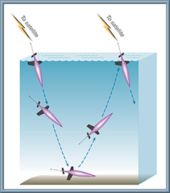 |
Figure 2 shows an illustration of the Seaglider and its operation, as well as an example of a Seaglider repeat section.
From our "Naco Gliderpage" you will find the data made available in near real time. The first Seaglider section conducted at the Svinøy section in January 2009 is available from (http://iop.apl.washington.edu/seaglider/sections.php?glider=160&mission=SvinoySection_Jan09).
This observational infrastructure is supplemented by moored current meters in a key reference location at the Svinøy section. We have instrumented 1 fixed point ADCP bottom mounted current meters attached to a surface data and transmission buoy. By using telemetry, current records and environmental data from the core of the NwAC are transmitted and available on internet in near real time. Deployment and recovery costs for the fixed point moorings are covered by the Geophysical Institute. You can follow the incoming data from the Naco buoy from our "Naco Buoy page".
There are two main reasons for offering such fixed point observations within the frame of NACO:
i) to augment the value of the glider observations by providing a connection to existing long
time series and a reference point for future measurements in the area, and
ii) to augment the
value of the glider observations by providing data with proven technology in a key area which
has proven particularly challenging for gliders.
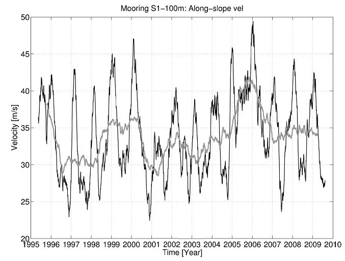
The reference measurements are located at the Svinøy section in at the steep shallow part of the continental shelf (position S1 62°48`N, 4°15`E, depth 500m. A reference time series from this location is given in Figure 2. The present need for such supplement to gliders has been clarified from experience with gliders in the area and related experience elsewhere.
The infrastructure project therefore consists of the following components:
1. Gliders
2. Facilities for deployment and recovery of gliders
3. Real time data capability for supporting reference moorings
4. Facilities and data systems for flight control and data handling
The Geophysical Institute through the project manager is a member of EGO which has developed into a global forum for glider observatory development and will be exploited further for competence building, sharing of experiences and development of techniques.
Monitoring temperature and salinity in the wider area is important since it is likely that the eddy activity responds to temperature variations in the NwAC through baroclinic instability, and since such wider mapping provides a context for high precision single point measurements of multiple parameters such as at PolarBuoy. The research infrastructure is localized in Norwegian waters. The research infrastructure is a national facility in collaboration with international networks. The observational data are made electronically available for users.
The primary disciplines and user groups for analysis of individual parts of the observational data sets are physical oceanography, ecosystem resource studies and climate science which will be stimulated to join forces by this infrastructure. The user community extends to chemical and biological oceanographers and Earth System modellers who will use the observational data as foundation and support for their own research.
[PREV CHAPTER] [NEXT CHAPTER]